Space-Based RF Geolocation: The "Electronic Ears" of LEO
- Oct 31, 2025
- 6 min read
Without This Technology, Next-Generation Capabilities Remain Grounded
Imagine you are in a vast, pitch-black, and noisy room, and you must pinpoint the exact location of an adversary whispering in a corner. You cannot see them (like an optical satellite at night), nor can you sweep the room with a flashlight (like an active radar satellite), as that would give away your own position. Your only option is to place three or four highly sensitive microphones at different corners of the room.
When the adversary speaks, each microphone will receive that same sound at a fractionally different time (nanoseconds apart). By precisely calculating these "time differences," you can instantly triangulate the source of the sound.
This is the core principle of Space-based RF Geolocation. It is not just about "hearing" a signal; it is about "locating" its origin. Without this technology, the U.S. Space Force's Space Domain Awareness (SDA) architecture would be deaf, unable to detect an adversary's electronic attack (e.g., GPS jamming) at its source. Navies would be blind to "dark ships" that have disabled their AIS transponders but are still using navigation radar or satellite phones. This technology is the linchpin that shifts space operations from passive observation to active deterrence, providing dominance over the electromagnetic spectrum.
The Core Tech Explained: Principles and A Paradigm-Shifting Challenge
The Old Bottlenecks: Why Traditional Architectures Can't Counter New Threats
For decades, space-based RF surveillance (Signals Intelligence, or SIGINT) relied on a few "golden satellites." These bus-sized, multi-billion-dollar assets, typically placed in Geostationary (GEO) or Highly Elliptical (HEO) orbits, provided immense coverage (one GEO satellite can see one-third of the globe).
However, this architecture has three fundamental flaws for the modern era:
High-Value, Vulnerable Targets: These are exquisite national assets, making them the most logical and high-value targets for an adversary in a conflict.
Lack of Tactical Timeliness: From 36,000 km away, their ability to geolocate faint, terrestrial signals is limited. More importantly, they lack the persistent revisit rates needed to track dynamic, tactical threats.
Poor Geolocation: A single satellite "hearing" a signal can only determine a general line of bearing, not a precise "X-marks-the-spot" location.
As the LEO domain becomes the new battlefield and terrestrial threats (mobile radars, jammers) become smaller and more agile, this legacy architecture is no longer sufficient.
What Is the Core Principle?
The next-generation solution is a paradigm shift from "single and exquisite" to "many and proliferated." It utilizes a LEO constellation for collaborative detection. The power of this system is not in any single satellite, but in the precise spatio-temporal relationship between the satellites.
The primary techniques are known as TDOA/FDOA Triangulation:
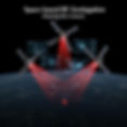
TDOA (Time Difference of Arrival): This is the "microphone" analogy. A cluster of three or more satellites flies in a precise formation. When they all receive the same signal pulse from the ground (e.g., a radar emitter), the system measures the time difference of that signal's arrival at each satellite, down to picosecond (trillionth of a second) accuracy. This calculation defines a hyperbolic curve on the Earth's surface where the emitter must be.
FDOA (Frequency Difference of Arrival): Because the satellites are moving at high speed (7+ km/s) relative to the ground emitter, they experience a Doppler shift (like an ambulance siren changing pitch as it passes). Each satellite in the cluster, having a slightly different velocity vector relative to the target, will measure a different Doppler-shifted frequency. This calculation provides a second hyperbolic curve.
The intersection of the TDOA and FDOA curves provides the precise geolocation of the RF emitter. This design masterfully leverages the physics of LEO (high speed and proximity) to turn principles of relativity and the Doppler effect into tactical, high-precision intelligence.
The Breakthroughs of the New Generation
This new LEO-based paradigm delivers revolutionary breakthroughs:
High Precision and Sensitivity: LEO satellites are close enough to detect very faint signals. The multi-satellite baseline allows for geolocation accuracy to be improved from tens of kilometers to the tactical (sub-kilometer) level.
High Revisit and Persistence: A constellation of dozens of satellites ensures that any point on Earth is monitored multiple times per hour, providing a near-real-time picture of the RF environment.
High Resilience and Low Cost: The architecture is disaggregated. The loss of one satellite in a 50-satellite constellation only temporarily degrades accuracy in one area; it doesn't kill the mission. This proliferation mitigates mission risk against kinetic or electronic attacks.
Industry Impact and Applications
The Blueprint to Reality: Challenges from R&D to Operations
Achieving nanosecond-level synchronization in orbit to perform precision triangulation places extreme demands on the satellite's payload, platform, and processing.
Challenge 1: Miniaturized, Wideband, and Sensitive RF Payloads
The challenge is to shrink a highly sensitive RF collection system—which traditionally required a large aircraft or ground station—down to the Size, Weight, and Power (SWaP) constraints of a SmallSat, all while being able to listen to everything from VHF walkie-talkies to Ka-band radars.
Core Components & Technical Requirements: The payload's heart is an ultra-wideband Software-Defined Radio (SDR) and highly sensitive antenna arrays. The key enabling component is the RF System-on-Chip (RFSoC), which integrates high-speed ADCs and powerful FPGA processing fabric on a single chip to digitize and analyze vast swaths of spectrum in real-time.
Challenge 2: Centimeter-Level Precision Timing and Orbit Determination (PNT)
The success or failure of TDOA/FDOA hinges on the system's ability to know the exact position and time of each satellite at the moment of signal intercept. If the satellites' own positions are uncertain, the resulting ground geolocation will be useless.
Core Tools & Technical Requirements: This demands that each satellite carry high-precision, dual-frequency GNSS receivers and miniaturized atomic clocks (or highly stable oscillators). Critically, the cluster must be time-synchronized via Inter-Satellite Links (OISLs) to picosecond levels. This ensures all satellites are operating from a common, highly reliable time-base, which is fundamental to the triangulation calculation.
Challenge 3: On-Board Processing and Fusion of Massive Data Volumes
An RF constellation, listening to the entire globe 24/7, generates an unfathomable volume of raw data (known as IQ data). It is impossible to downlink all of it.
Core Tools & Technical Requirements: Edge computing on orbit is a necessity. On-board FPGAs or AI accelerators must run machine learning algorithms to autonomously sift through the noise, classify signals of interest (e.g., "This is the signature of an S-400 radar"), and only downlink the alert. This "tip-and-cue" capability, where the satellite provides a heads-up rather than raw data, is what accelerates the capability deployment from hours to minutes.
Killer Applications: Which Missions Depend on This?
Electronic Warfare (EW) / Space Domain Awareness (SDA): Providing early warning by detecting and locating adversary GPS or SATCOM jammers, cueing electronic countermeasures.
Maritime Domain Awareness (MDA): Tracking "dark ships" that go silent on AIS to conduct illegal fishing, smuggling, or naval maneuvers.
National Security & ISR: Providing Indications & Warnings (I&W) of a conflict by monitoring the activation of border-control radars and communications.
Emergency Response: Locating Emergency Position Indicating Radio Beacons (EPIRBs) or even personal mobile phones in disaster zones where terrestrial networks are down.
The Future: Challenges to Adoption and the Next Wave
Today's commercial RF constellations (e.g., HawkEye 360, Kleos Space) offer geolocation accuracy in the single-kilometer range. The next frontier is to fly larger clusters in tighter formations with even better clock synchronization, pushing accuracy below 100 meters, making it tactically actionable. The future is sensor fusion: an RF constellation will provide the wide-area "tip-off," which then autonomously cues a high-resolution optical or SAR satellite for visual confirmation, creating a fully automated, multi-domain intelligence chain.
Investor's Take: Why the "Picks and Shovels" Play Is Compelling
Space-based RF sensing is both a classic Data-as-a-Service (DaaS) market and a high-tech hardware play. For investors, the value proposition is twofold.
First, the data itself is the product. Government defense and intelligence agencies, coast guards, and even financial institutions tracking global commodities are willing to pay a premium for this exclusive, all-weather RF intelligence. Second, the barrier to entry for building these "ears" is extremely high. The companies that have mastered the wideband RF payloads, the precision clock synchronization, and the on-board AI algorithms have built a deep technological moat.
Investing in this sector is an investment in "dominance of the electromagnetic spectrum." In an age where everything is connected and emitting RF signals, the ability to "see" and "understand" those signals from space is the ultimate strategic advantage. These suppliers of "data" and "data-gathering tools" are undeniably one of the most critical enabling segments of the new space economy.
If this Aminext article was even a little bit helpful, would you pretty please do me a huge favor and give it a like or share? Every single bit of your support is the fuel that keeps me going, hunting down and breaking down the latest tech trends for you. Thank you so, so much.